Top 10 Commonly Confused Words in Geothermal Energy

Introduction: The Fascinating World of Geothermal Energy

Today, we’re diving into the captivating realm of geothermal energy. But before we delve deeper, it’s essential to clarify some commonly confused words that often arise in this field. So, let’s get started!

1. Geothermal vs. Fossil Fuels: The Difference

While both geothermal energy and fossil fuels involve harnessing the Earth’s resources, they differ significantly. Geothermal energy taps into the Earth’s natural heat, while fossil fuels rely on ancient organic matter. Understanding this distinction is crucial for comprehending the environmental benefits of geothermal energy.

2. Geothermal Heat Pumps: Heat Transfer Marvels

Geothermal heat pumps, often mistaken for traditional heating systems, are a marvel of heat transfer. Unlike conventional methods, these pumps extract heat from the ground during winter and release it during summer. This efficient process not only saves energy but also reduces greenhouse gas emissions.

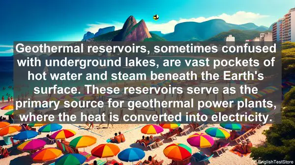
3. Geothermal Reservoirs: Nature’s Underground Storehouses

Geothermal reservoirs, sometimes confused with underground lakes, are vast pockets of hot water and steam beneath the Earth’s surface. These reservoirs serve as the primary source for geothermal power plants, where the heat is converted into electricity.

4. Geothermal Gradient: The Earth’s Temperature Profile

The geothermal gradient refers to the Earth’s temperature variation with depth. On average, the temperature increases by about 25-30 degrees Celsius per kilometer. This gradient is a crucial factor in determining the viability of geothermal resources in a particular region.

5. Geothermal Direct Use: Beyond Electricity Generation

While geothermal energy is renowned for its electricity generation potential, it has numerous direct uses as well. These include heating buildings, drying crops, and even spa treatments. Exploring these diverse applications showcases the versatility of geothermal energy.

6. Geothermal Power Plants: The Different Types

Geothermal power plants come in various forms, including dry steam, flash steam, and binary cycle plants. Each utilizes different technologies to harness the Earth’s heat. Understanding these distinctions provides insights into the efficiency and environmental impact of each type.

7. Geothermal Exploration: Unveiling the Subsurface

Geothermal exploration involves a range of techniques, from geological surveys to drilling. These methods help identify potential geothermal resources and assess their feasibility. The exploration phase is a crucial step in any geothermal project.

8. Geothermal Emissions: A Cleaner Energy Option

Compared to fossil fuels, geothermal energy is a cleaner option. While there are some emissions associated with geothermal power plants, they are significantly lower than those from coal or natural gas plants. This aspect highlights the environmental advantages of geothermal energy.

9. Geothermal and Solar: A Synergistic Pair

Geothermal and solar energy complement each other exceptionally well. In regions where sunlight is abundant, solar power can be harnessed during the day, while geothermal energy provides a consistent source of electricity round the clock. This combination ensures a reliable and sustainable energy supply.

10. Geothermal Potential: A Global Resource

Geothermal energy has immense potential worldwide. While some countries, like Iceland, have already tapped into this resource extensively, many others are yet to fully explore it. Recognizing this potential is crucial for a sustainable and diversified energy future.

Top 10 Commonly Confused Words in Geotechnical Engineering

Introduction

Welcome to our geotechnical engineering class. Today, we’ll be diving into a topic that often trips up students: commonly confused words. Let’s get started!

1. Soil vs. Sediment

While both terms refer to earth materials, there’s a key difference. Soil consists of organic and inorganic matter, while sediment is primarily made up of particles that settle at the bottom of a liquid. Understanding this distinction is crucial when analyzing the composition of a site.

2. Bearing Capacity vs. Shear Strength

Bearing capacity refers to the maximum load a soil can support, while shear strength measures its resistance to sliding. These concepts are vital when designing foundations, as a miscalculation can lead to structural failure.

3. Compaction vs. Consolidation

Both processes involve reducing soil volume, but they occur under different conditions. Compaction is achieved by mechanical means, like rolling or vibrating, while consolidation is a natural process that happens over time due to the weight of overlying soil or structures.

4. Slope vs. Incline

Although often used interchangeably, there’s a slight difference. A slope refers to a natural landform, like a hill, while an incline is an artificially created surface, such as a ramp or a road. This differentiation is crucial when assessing stability.

5. Permeability vs. Porosity

Permeability measures how easily fluids can flow through a material, while porosity refers to the void spaces within it. While both relate to a substance’s ability to hold or transmit water, they have distinct implications in geotechnical analysis.

6. Groundwater vs. Surface Water

Groundwater is the water present beneath the Earth’s surface, while surface water refers to bodies like rivers, lakes, or oceans. Understanding the distinction is crucial when assessing the potential impact of water on a project site.

7. Excavation vs. Trenching

Both involve digging, but the purpose and dimensions differ. Excavation is a broader term, often used for larger-scale projects, while trenching refers to a narrow and deep excavation. The choice depends on the project’s requirements.

8. Shallow Foundation vs. Deep Foundation

Foundations are crucial for any structure, and their depth is a key consideration. Shallow foundations, like footings, are used when the upper soil layers have sufficient bearing capacity. Deep foundations, such as piles, are necessary when the load needs to be transferred to deeper, more stable soil or rock layers.

9. Geosynthetics vs. Geotextiles

Both are synthetic materials used in geotechnical applications, but they have different functions. Geosynthetics is an umbrella term that includes geotextiles, as well as other materials like geomembranes and geogrids. Geotextiles, specifically, are used for filtration, drainage, or reinforcement purposes.

10. Settlement vs. Subsidence

While both refer to the downward movement of the ground, settlement is a gradual process that occurs uniformly, often due to the consolidation of soil. Subsidence, on the other hand, is a more sudden and localized phenomenon, often caused by human activities like mining or groundwater extraction.

Top 10 Commonly Confused Words in Geospatial Science

Introduction

Today, we’re going to dive into the fascinating world of geospatial science. But before we begin, let’s clear up some common word confusions that often arise in this field.

1. Latitude vs. Longitude

Latitude and longitude are both crucial for locating points on the Earth’s surface. However, latitude measures the distance north or south of the equator, while longitude measures the distance east or west of the prime meridian.

2. Accuracy vs. Precision

Accuracy refers to how close a measured value is to the true value, while precision relates to the consistency of repeated measurements. In geospatial science, both are vital for reliable data analysis.

3. GIS vs. GPS

GIS (Geographic Information System) and GPS (Global Positioning System) are often used interchangeably, but they have distinct roles. GIS deals with data management and analysis, while GPS focuses on positioning and navigation.

4. Remote Sensing vs. Aerial Photography

Remote sensing involves gathering data about the Earth’s surface from a distance, using sensors on satellites or aircraft. Aerial photography, on the other hand, captures images of the Earth’s surface from an aircraft.

5. Georeferencing vs. Geocoding

Georeferencing involves aligning a digital map or image with real-world coordinates. Geocoding, on the other hand, is the process of assigning geographical coordinates to a specific address or location.

6. Topographic vs. Thematic Maps

Topographic maps provide detailed information about the physical features of an area, such as elevation and landforms. Thematic maps, on the other hand, focus on specific themes, like population density or vegetation.

7. Spatial Resolution vs. Spectral Resolution

Spatial resolution refers to the level of detail in an image, while spectral resolution relates to the range of wavelengths it can capture. Both are essential for accurate image interpretation in geospatial analysis.

8. Interpolation vs. Extrapolation

Interpolation involves estimating values within a known range, while extrapolation predicts values outside that range. In geospatial science, both techniques are used for spatial data analysis and modeling.

9. Vector vs. Raster Data

Vector data represents geographic features as points, lines, or polygons, while raster data uses a grid of cells to represent the surface. Each has its strengths, and the choice depends on the analysis requirements.

10. Geodetic vs. Cartesian Coordinates

Geodetic coordinates, such as latitude and longitude, are based on the Earth’s curved surface. Cartesian coordinates, like x and y, use a flat, two-dimensional plane. The choice depends on the application and accuracy needed.

Top 10 Commonly Confused Words in Geospatial Intelligence

Introduction

Welcome to today’s lesson on Geospatial Intelligence. In this lesson, we’ll be focusing on a topic that often trips up even the most experienced professionals: commonly confused words. Understanding these distinctions is essential for effective communication and analysis in the field. So, let’s dive in!

1. Accuracy vs. Precision

While accuracy refers to how close a measurement is to the true value, precision relates to the consistency and reproducibility of that measurement. In Geospatial Intelligence, accuracy is crucial for reliable data, while precision ensures that results are consistently reproducible.

2. Latitude vs. Longitude

Latitude and longitude are the two primary coordinates used to pinpoint a location on Earth. Latitude measures the distance north or south of the equator, while longitude indicates the distance east or west of the prime meridian.

3. GIS vs. GPS

GIS, or Geographic Information System, is a software tool used for capturing, analyzing, and visualizing geospatial data. On the other hand, GPS, or Global Positioning System, is a network of satellites that provides precise location information.

4. Remote Sensing vs. Aerial Photography

Remote sensing involves gathering data about the Earth’s surface without physical contact, often using satellites or aircraft. Aerial photography, as the name suggests, captures images of the Earth from above using cameras mounted on aircraft.

5. Georeferencing vs. Geocoding

Georeferencing involves aligning a dataset with a known coordinate system, allowing it to be accurately placed on a map. Geocoding, on the other hand, is the process of converting an address or place name into geographic coordinates.

6. Topology vs. Topography

Topology refers to the spatial relationships and connectivity between geographic features. Topography, on the other hand, focuses on the physical features and elevation of the Earth’s surface.

7. Vector vs. Raster

Vector and raster are two common data formats in Geospatial Intelligence. Vector data uses points, lines, and polygons to represent features, while raster data is made up of a grid of cells, with each cell containing a value.

8. Resolution vs. Scale

Resolution refers to the level of detail in an image or dataset. Scale, on the other hand, relates to the ratio between a distance on a map and the corresponding distance on the ground.

9. Metadata vs. Attribute

Metadata provides information about a dataset, such as its source, accuracy, and creation date. Attributes, on the other hand, are the specific characteristics or properties of a geographic feature.

10. Buffer vs. Overlay

Buffering involves creating a zone of a specified distance around a geographic feature. Overlay, on the other hand, combines multiple layers or datasets to create a composite map, often revealing patterns or relationships.

Top 10 Commonly Confused Words in Geospatial Analysis

Introduction

Welcome to our geospatial analysis class. Today, we’ll be discussing the top 10 commonly confused words in this field. Understanding these terms is crucial for accurate analysis. So, let’s dive in!

1. Coordinate vs. Coordinate System

The term ‘coordinate’ refers to a single point’s location, while a ‘coordinate system’ is a reference framework that defines how coordinates are measured and displayed. Remember, a coordinate system is the larger concept.

2. Accuracy vs. Precision

Accuracy refers to how close a measured value is to the true value, while precision relates to the consistency of repeated measurements. In geospatial analysis, both are vital for reliable results.

3. Projection vs. Datum

A ‘projection’ is a method to represent the Earth’s curved surface on a flat map, while a ‘datum’ is a reference point or surface used as a starting point for measurements. Projections deal with map distortion, while datums focus on the reference frame.

4. Vector vs. Raster

Vector data represents features using points, lines, and polygons, while raster data is made up of a grid of cells, each containing a value. The choice between the two depends on the type of analysis and the data’s nature.

5. Buffer vs. Overlay

A ‘buffer’ creates a zone of a specified distance around a feature, while an ‘overlay’ combines multiple layers to create a new one, often revealing relationships. Both are powerful tools, but with different purposes.

6. Interpolation vs. Extrapolation

Interpolation estimates values within a known range, while extrapolation predicts values beyond the known range. In geospatial analysis, both techniques are used to fill data gaps or make predictions.

7. Spatial Autocorrelation vs. Spatial Heterogeneity

Spatial autocorrelation refers to the similarity of attribute values in neighboring locations, while spatial heterogeneity indicates the diversity or dissimilarity. Understanding these concepts helps identify patterns and hotspots.

8. Geocoding vs. Reverse Geocoding

Geocoding converts an address into geographic coordinates, while reverse geocoding does the opposite, translating coordinates into an address. Both are essential for mapping and spatial analysis.

9. Georeferencing vs. Geotagging

Georeferencing involves aligning a raster or scanned map with real-world coordinates, while geotagging adds geographic metadata, like coordinates, to a digital file. Both ensure spatial context and accuracy.

10. Spatial Join vs. Attribute Join

A spatial join combines two datasets based on their spatial relationship, while an attribute join merges them using a common attribute. Both operations enrich the data, but in different ways.

Top 10 Commonly Confused Words in Geopolitics

Introduction

Welcome to today’s lesson on geopolitics. In this lesson, we’ll be discussing the top 10 commonly confused words in this fascinating field. Understanding these terms is crucial for comprehending global affairs. So, let’s dive in!

1. Nation vs. State

The terms ‘nation’ and ‘state’ are often used interchangeably, but they have distinct meanings. A nation refers to a group of people who share a common culture, language, or history. On the other hand, a state is a political entity with defined borders and a governing authority. While a nation-state is a combination of both, not all nations have their own states, and not all states are homogenous nations.

2. Power vs. Influence

Power and influence are related but differ in their nature. Power is the ability to make others do something, often through coercion or force. Influence, on the other hand, is the capacity to shape opinions, decisions, or actions without direct control. While power can be temporary or situational, influence is often built over time and can have long-lasting effects.

3. Globalization vs. Localization

Globalization refers to the increasing interconnectedness of the world, where ideas, goods, and people flow across borders. It often leads to a homogenization of cultures and economies. Localization, on the other hand, emphasizes local identity, traditions, and self-sufficiency. While globalization can bring economic benefits, localization aims to preserve diversity and protect local industries.

4. Democracy vs. Republic

Both democracy and republic are forms of government, but they have different structures. In a democracy, decisions are made directly by the people through voting. In a republic, the people elect representatives who make decisions on their behalf. While all republics are democracies, not all democracies are republics. For example, a direct democracy is not a republic.

5. Colonialism vs. Imperialism

Colonialism and imperialism are often used interchangeably, but they have distinct historical contexts. Colonialism refers to the establishment and maintenance of colonies by a foreign power. It often involves the exploitation of resources and the imposition of cultural norms. Imperialism, on the other hand, is the broader concept of extending a nation’s power and influence over other territories, which can include non-colonial methods like economic dominance.

6. Terrorism vs. Insurgency

Terrorism and insurgency are both forms of political violence, but they differ in their objectives and methods. Terrorism aims to create fear and panic among the general population, often through indiscriminate attacks. Insurgency, on the other hand, is a broader term that refers to an armed rebellion against a government or occupying force. While all terrorists can be considered insurgents, not all insurgents resort to terrorism.

7. Diplomacy vs. Foreign Policy

Diplomacy and foreign policy are closely related but have different scopes. Diplomacy refers to the practice of conducting negotiations and maintaining relations between countries. It often involves diplomats and ambassadors. Foreign policy, on the other hand, is the broader strategy and goals that a country pursues in its interactions with other nations. Diplomacy is one of the tools used to implement foreign policy.

8. Genocide vs. Ethnic Cleansing

Both genocide and ethnic cleansing involve the targeting of specific ethnic or religious groups, but they differ in their intent and scope. Genocide aims to completely eliminate a group, often through mass killings. Ethnic cleansing, while also involving forced displacement and violence, may not necessarily seek the complete annihilation of a group. Both are grave human rights violations.

9. Hegemony vs. Supremacy

Hegemony and supremacy both refer to dominance, but they have different connotations. Hegemony is the dominance of one group or state over others, often achieved through economic or cultural means. It can be seen as a form of leadership. Supremacy, on the other hand, implies the belief in the inherent superiority of one group over others, often based on race or ideology. It can be more exclusionary and oppressive.

10. Balance of Power vs. Collective Security

Both balance of power and collective security are strategies to maintain international stability, but they have different approaches. Balance of power relies on the distribution of power among states, where no single state becomes too dominant. Collective security, on the other hand, emphasizes cooperation and the collective response of multiple states to a threat. It aims to address the root causes of conflicts.

Top 10 Commonly Confused Words in Geophysics

Introduction: The Importance of Clear Communication in Geophysics

As geophysicists, our work involves studying the Earth’s physical properties and processes. But it’s not just about collecting data; we also need to effectively communicate our findings. That’s why understanding the correct usage of certain words is crucial. In this lesson, we’ll explore the top 10 words that often trip up students. Let’s get started!

1. Epicenter vs. Hypocenter: Understanding Earthquake Terminology

When discussing earthquakes, the terms ‘epicenter’ and ‘hypocenter’ often come up. The epicenter refers to the point on the Earth’s surface directly above the earthquake’s focus, or hypocenter. While the epicenter is what we usually hear about in news reports, it’s the hypocenter that’s of more significance to us as geophysicists, as it’s the actual point where the earthquake originates.

2. Velocity vs. Speed: Not Just Synonyms

In everyday language, ‘velocity’ and ‘speed’ are often used interchangeably. However, in geophysics, they have distinct meanings. Speed refers to the distance traveled per unit of time, while velocity not only considers the magnitude of the speed but also the direction. So, while two objects may have the same speed, their velocities can be different if they’re moving in different directions.

3. Weather vs. Climate: The Difference in Time Scales

Weather and climate are terms we often hear, but they refer to different time scales. Weather describes the atmospheric conditions over a short period, such as a day or a week. On the other hand, climate refers to the long-term patterns and averages of weather in a specific region. Understanding this distinction is crucial when analyzing geophysical data for climate studies.

4. Conduction vs. Convection: Modes of Heat Transfer

Heat transfer is a fundamental concept in geophysics. Conduction and convection are two primary modes of heat transfer. Conduction occurs when heat is transferred through a material without any actual movement of the material itself. Convection, on the other hand, involves the transfer of heat through the movement of the material, typically in a fluid state. Both processes play significant roles in the Earth’s energy balance.

5. Latitude vs. Longitude: Navigating the Earth’s Grid

Latitude and longitude are the coordinates used to pinpoint locations on the Earth’s surface. While both are measured in degrees, they represent different aspects. Latitude measures the distance north or south of the equator, while longitude measures the distance east or west of the prime meridian. Together, they provide a precise way to specify any location on the planet.

6. Magnitude vs. Intensity: Assessing Earthquake Effects

When we talk about the strength of an earthquake, we often use the terms ‘magnitude’ and ‘intensity.’ Magnitude refers to the energy released at the earthquake’s source, as measured by seismographs. Intensity, on the other hand, describes the effects of the earthquake at a particular location, taking into account factors like building damage and human perception. So, while two earthquakes may have the same magnitude, their intensities can vary.

7. Isostasy vs. Lithostatic Pressure: Balancing Forces in the Earth’s Crust

The Earth’s crust is subject to various forces, and two important ones are isostasy and lithostatic pressure. Isostasy refers to the equilibrium between the crust and the underlying mantle, with the less dense crust ‘floating’ on the denser mantle. Lithostatic pressure, on the other hand, is the pressure exerted by the overlying rocks due to their weight. Understanding these concepts helps us comprehend the dynamic nature of the Earth’s crust.

8. Geoid vs. Ellipsoid: Models of the Earth’s Shape

When we think of the Earth’s shape, we often imagine a perfect sphere. However, in reality, the Earth is not a perfect sphere but an ellipsoid, with variations in its shape. The geoid, on the other hand, is a model that represents the Earth’s shape, taking into account factors like gravity and the distribution of mass. Both the geoid and the ellipsoid are essential for accurate geodetic measurements.

9. Anomaly vs. Background: Identifying Deviations in Data

In geophysics, we often analyze data to identify anomalies, which are deviations from the expected or ‘background’ values. An anomaly can indicate the presence of a geological feature or a change in a physical property. By distinguishing anomalies from the background, we can gain valuable insights into the Earth’s subsurface.

10. Moho vs. Mohorovicic Discontinuity: The Boundary Between Crust and Mantle

The Moho, short for Mohorovicic discontinuity, is a significant boundary in the Earth’s interior. It marks the boundary between the crust and the underlying mantle. Named after the Croatian seismologist Andrija Mohorovicic, the Moho is not a simple, uniform boundary but rather a zone of transition with variations in its depth and characteristics.

Top 10 Commonly Confused Words in Geophysical Fluid Dynamics

Introduction: The Language of Geophysical Fluid Dynamics

Geophysical Fluid Dynamics is a complex field that deals with the study of fluid motion in the Earth’s atmosphere and oceans. Like any scientific discipline, it has its own set of specialized vocabulary. However, some words in this domain are often used interchangeably or misinterpreted, leading to misunderstandings. Let’s begin our exploration of these commonly confused terms.

1. Viscosity vs. Vorticity

Viscosity refers to a fluid’s resistance to flow, while vorticity is a measure of the local rotation of fluid elements. Although both are related to fluid motion, they represent different aspects. Viscosity determines the fluid’s internal friction, while vorticity indicates the presence of fluid rotation. Understanding this distinction is crucial for analyzing various flow phenomena.

2. Advection vs. Diffusion

Advection and diffusion are two fundamental processes in fluid dynamics. Advection refers to the transport of a property by the bulk motion of the fluid, while diffusion involves the gradual mixing of the property due to molecular motion. In simpler terms, advection is like carrying a dye in a flowing river, while diffusion is the gradual spreading of that dye over time. Both processes play significant roles in the Earth’s fluid systems.

3. Convection vs. Conduction

Convection and conduction are modes of heat transfer. Convection involves the transfer of heat through the movement of fluid, while conduction is the transfer of heat through direct contact between particles. A classic example of convection is the heating of a room through a radiator, where the warm air rises, creating a circulation pattern. Conduction, on the other hand, is like touching a hot object and feeling the heat transfer.

4. Equilibrium vs. Steady State

Equilibrium and steady state are often used interchangeably, but they have distinct meanings. Equilibrium refers to a balanced state where there is no net change, while steady state implies a condition where the system’s properties remain constant over time, despite continuous input and output. Understanding these terms is crucial for studying the long-term behavior of geophysical systems.

5. Isobar vs. Isotherm

Isobars and isotherms are lines used in weather maps. Isobars connect points of equal atmospheric pressure, while isotherms connect points of equal temperature. By analyzing the distribution of these lines, meteorologists can infer the weather conditions and identify features like high and low-pressure systems. Confusing these terms can lead to inaccurate weather predictions.

6. Anomaly vs. Deviation

Anomaly and deviation are often used in the context of data analysis. Anomaly refers to a departure from the expected or normal value, while deviation is a measure of the difference between an observed value and a reference value. Anomaly detection is crucial in identifying unusual patterns or events in geophysical data, while deviation helps quantify the extent of the difference.

7. Upwelling vs. Downwelling

Upwelling and downwelling are terms used in oceanography. Upwelling refers to the upward movement of deep, nutrient-rich water to the surface, while downwelling is the opposite, where surface water sinks to deeper layers. These vertical movements play a vital role in nutrient distribution, marine ecosystems, and even climate patterns.

8. Rossby Wave vs. Kelvin Wave

Rossby waves and Kelvin waves are types of waves that occur in rotating fluid systems. Rossby waves are large-scale, meandering waves that are influenced by the Earth’s rotation, while Kelvin waves are fast-moving, shallow waves that are driven by changes in the ocean’s thermocline. Both types of waves have significant impacts on weather and ocean circulation.

9. Stratification vs. Mixing

Stratification and mixing are processes that affect the vertical structure of fluids. Stratification refers to the layering of fluids with different properties, such as temperature or density. Mixing, on the other hand, involves the vertical exchange of these properties, leading to a more uniform distribution. Understanding these processes is crucial for studying phenomena like oceanic overturning and atmospheric stability.

10. Geostrophic vs. Ageostrophic

Geostrophic and ageostrophic winds are terms used in meteorology. Geostrophic winds are large-scale, horizontal winds that result from a balance between the pressure gradient force and the Coriolis effect. Ageostrophic winds, on the other hand, deviate from this balance and are influenced by other factors like friction. Distinguishing between these wind types is essential for accurate weather analysis.

Top 10 Commonly Confused Words in Geomicrobiology

Introduction

Welcome to today’s lesson. Geomicrobiology is a fascinating field, but it can be challenging, especially when it comes to the terminology. In this lesson, we’ll be discussing the top 10 commonly confused words in geomicrobiology. By the end of this lesson, you’ll have a better grasp of these terms and their nuances.

1. Biomineralization vs. Bioremediation

Biomineralization and bioremediation are two terms that are often interchanged, but they have distinct meanings. Biomineralization refers to the process by which microorganisms form minerals, while bioremediation is the use of microorganisms to remove pollutants from the environment. Understanding the difference between these two terms is crucial in geomicrobiology.

2. Aerobic vs. Anaerobic

Aerobic and anaerobic are terms used to describe the presence or absence of oxygen. In geomicrobiology, these terms are essential when studying microbial metabolism. Aerobic microorganisms require oxygen for their metabolic processes, while anaerobic microorganisms can survive and thrive in the absence of oxygen.

3. Autotroph vs. Heterotroph

Autotrophs and heterotrophs are terms that categorize organisms based on their carbon source. Autotrophs can synthesize organic compounds from inorganic sources, such as carbon dioxide, while heterotrophs rely on organic compounds produced by other organisms. These terms are crucial in understanding microbial food webs in geomicrobiology.

4. Syntrophy vs. Mutualism

Syntrophy and mutualism are two types of symbiotic relationships between microorganisms. Syntrophy refers to a relationship where two or more microorganisms work together, with one organism benefiting from the metabolic byproducts of the other. Mutualism, on the other hand, is a mutually beneficial relationship where both organisms gain from the interaction. These relationships play a vital role in microbial communities in various geomicrobial environments.

5. Chemotaxis vs. Phototaxis

Chemotaxis and phototaxis are terms used to describe the movement of microorganisms in response to chemical or light stimuli, respectively. Understanding these terms is crucial when studying microbial motility and their ability to navigate in their environment.

6. Biofilm vs. Planktonic

Biofilms and planktonic cells are two forms of microbial growth. Biofilms are communities of microorganisms attached to a surface, while planktonic cells are free-floating. Each form has its advantages and disadvantages, and studying their dynamics is essential in geomicrobiology.

7. Genotype vs. Phenotype

Genotype and phenotype are terms used to describe the genetic and observable characteristics of an organism, respectively. In geomicrobiology, understanding the relationship between genotype and phenotype is crucial when studying microbial adaptations to different environments.

8. Biogeochemical Cycling vs. Bioremediation

Biogeochemical cycling and bioremediation are two processes that involve microbial activities. Biogeochemical cycling refers to the cycling of elements, such as carbon, nitrogen, and sulfur, through biological, geological, and chemical processes. Bioremediation, as mentioned earlier, is the use of microorganisms to remove pollutants. While these processes are interconnected, they have distinct focuses in geomicrobiology.

9. Phylogeny vs. Taxonomy

Phylogeny and taxonomy are terms used to classify and understand the relationships between organisms. Phylogeny focuses on the evolutionary history and genetic relationships, while taxonomy involves the classification and naming of organisms. Both concepts are essential in geomicrobiology to understand the diversity and evolutionary relationships of microorganisms.

10. Metagenomics vs. Metatranscriptomics

Metagenomics and metatranscriptomics are two approaches used in studying microbial communities. Metagenomics involves analyzing the genetic material (DNA) present in an environmental sample, providing insights into the potential functions and diversity of the community. Metatranscriptomics, on the other hand, focuses on the analysis of the RNA, providing information about the active genes and metabolic processes. These approaches have revolutionized our understanding of microbial communities in geomicrobial environments.

Top 10 Commonly Confused Words in Geomatics

Introduction

Geomatics, with its vast array of technical terms, can sometimes be confusing. In this lesson, we’ll explore the top 10 commonly confused words in Geomatics. By the end, you’ll have a clearer understanding of these terms, which will undoubtedly benefit your studies and future career. Let’s dive in!

1. Accuracy vs. Precision

Accuracy and precision are often used interchangeably, but they have distinct meanings. Accuracy refers to how close a measurement is to the true value, while precision relates to the consistency and reproducibility of a measurement. In Geomatics, both are crucial. For example, a GPS receiver may have high precision, consistently providing the same coordinates, but if those coordinates are consistently off from the true location, the accuracy is compromised.

2. GIS vs. GPS

GIS, or Geographic Information System, and GPS, or Global Positioning System, are two commonly used terms. While they both deal with spatial data, they serve different purposes. GIS is a software system used to capture, store, analyze, and present spatial data, while GPS is a satellite-based navigation system that provides precise location information. In simpler terms, GIS is the tool, and GPS is one of the many data sources for GIS.

3. Remote Sensing vs. Aerial Photography

Remote sensing and aerial photography are often used in Geomatics for data acquisition. Remote sensing involves gathering information about an object or area without direct physical contact, using sensors on satellites or aircraft. On the other hand, aerial photography is the process of capturing images from an aircraft. While both methods provide valuable data, remote sensing offers a broader range of information, including non-visible spectra like infrared.

4. Geoid vs. Ellipsoid

When representing the Earth’s shape, two models are commonly used: the geoid and the ellipsoid. The geoid is an irregular surface that approximates mean sea level, while the ellipsoid is a mathematically defined smooth surface. The geoid is used as a reference for elevations, while the ellipsoid is used for calculations involving coordinates. Think of the geoid as the Earth’s true shape, and the ellipsoid as a simplified, smooth representation.

5. Topographic vs. Planimetric Maps

Topographic and planimetric maps are both used to represent the Earth’s surface, but they differ in the level of detail. Topographic maps include not only the horizontal positions of features but also their elevations, making them suitable for terrain analysis. Planimetric maps, on the other hand, focus solely on the horizontal positions of features, making them useful for urban planning or transportation studies where elevation data may not be necessary.

6. Datum vs. Coordinate System

In Geomatics, a datum and a coordinate system are essential components. A datum is a reference surface or model used to define the shape and orientation of the Earth, while a coordinate system is a framework for assigning coordinates to locations on the Earth’s surface. The datum provides the starting point, and the coordinate system allows for precise positioning. Without a consistent datum and coordinate system, spatial data would be meaningless.

7. Conflation vs. Registration

Conflation and registration are terms used in data integration. Conflation involves combining multiple datasets, often with overlapping features, to create a unified dataset. Registration, on the other hand, is the process of aligning different datasets to a common coordinate system. While both processes involve data merging, conflation focuses on feature integration, while registration focuses on spatial alignment.

8. Georeferencing vs. Geocoding

Georeferencing and geocoding are techniques used to associate spatial information with non-spatial data. Georeferencing involves assigning spatial coordinates to an image or map, aligning it with the Earth’s surface. Geocoding, on the other hand, involves converting textual addresses or place names into geographic coordinates. Both techniques are crucial for spatial analysis and visualization.

9. Orthophoto vs. Aerial Image

Orthophotos and aerial images are commonly used in mapping and analysis. An orthophoto is a geometrically corrected aerial image that has a consistent scale, allowing for accurate measurements. It removes distortions caused by terrain relief and camera tilt. An aerial image, on the other hand, may have distortions and is not suitable for precise measurements without further processing. Orthophotos are often used as basemaps for various applications.

10. LiDAR vs. Photogrammetry

LiDAR and photogrammetry are both techniques used for 3D data acquisition. LiDAR, which stands for Light Detection and Ranging, uses laser pulses to measure distances and create highly accurate 3D models. Photogrammetry, on the other hand, involves extracting 3D information from overlapping aerial or terrestrial images. While LiDAR provides accurate elevation data, photogrammetry can also capture detailed surface textures.